Content Search
Unicef india assam floods humanitarian situation report, 8 july 2022, attachments.

2nd wave of floods in Assam which started on 14 June has improved considerably. As of 7 July, 0.91 million people including 0.23 million children and 0.32 million women from 707 villages of 14/35 districts are affected. One hundred and eighty six lives lost and 37 people have been reported as missing.
There are 207 flood relief camps functioning with 91,594 people including 27,938 children, 156 pregnant/lactating mothers, and 4 persons with disability. Additionally, 39 relief distribution centers are reaching out to people with essential relief supplies. As per initial estimates, 18,262 houses have been fully damaged, and 121,731 have been partially damaged as on 7 July 2022.
UNICEF is extending technical support to respective government departments on response and early recovery actions through existing human resources and partners.
UNICEF will deploy five technical experts in Cachar, Dima Hasao, Lakhimpur, Bajali and Barpeta for three months to support District Disaster Management Authorities (DDMAs) to facilitate GO-NGO Coordination and social sector recovery starting from 15 July.
UNICEF’s partner, Oxfam India has so far completed distribution of 1009 hygiene kits and household water filtration units in Cachar and Hojai districts, constructed 14 temporary toilets, conducted hygiene promotion activities reaching 31,315 people. Four boat mounted water treatment units supported by UNCEF are functioning in Cachar.
UNICEF has entered a partnership with Caritas India to scale up WASH response in Nagaon and Barpeta districts. The support will include water treatment units, hygiene kits, household water filtration kits, disinfection of spot sources and temporary toilets.
UNICEF’s partner, Deshabandu Club is supporting DDMA of Cachar in relief camp management and Inter Agency Coordination through District Inter Agency Group, Cachar.
UNICEF’s partner, Save the Children has agreed to support school continuity, mental health and psychosocial support in four districts of Assam (Dima Hasao, Cachar, Hojai and Nalbari).
UNICEF’s partner, Rural Volunteer Centre has been conducting block level training of frontline workers, supporting Village Health Sanitation Day (VHSND) continuity, support DDMAs in operationalizing Child Friendly Spaces in Dhemaji, Lakhimpur and Majuli.
Situation in Numbers
230,491 Children affected by flood
(Source: Daily SitRep, FRIMS, ASDMA dated 07 July 2022)
906,000 People affected by flood in 707 villages of 14 districts
27,938 Children in 207 relief camps in 11 districts
305,565 People in 207 relief camps in 11 districts
186 deaths and 37 missing
18,262 houses fully damaged
121,731 houses partially damaged
Situation Overview & Humanitarian Needs
With overall reduction in rainfall, 2nd wave of floods in Assam that started on 14 June has improved considerably. As of 7 July, 0.91 million people including 0.23 million children and 0.32 million women from 707 villages of 14/35 districts are affected. One hundred and eighty-six lives lost, and 37 people have been reported as missing. As per media reports citing Assam State Disaster Management Authority (ASDMA) complied data, 63 child deaths due to floods (drowning) were reported since 14 May, with majority of deaths reported from Cachar and Nagaon districts.
There are 207 flood relief camps functioning with 91,594 people including 27,938 children, 156 pregnant/lactating mothers, and 4 persons with the disability. Additionally, 39 relief distribution centers are reaching out to people with essential relief supplies. As per initial estimates, 18,262 houses have been fully damaged, and 121,731 have been partially damaged as on 7 July 2022.
Government of India has released INR 3244 million to the state of Assam to supplement the ongoing response and recovery actions as well as preparedness for possible floods in the coming months.
Public Health measures including disinfection, chlorination of water sources, minor repairing of spot sources, piped water supply schemes and restoration of road communication are also ongoing.
Flood damage assessments by the government agencies are ongoing. The compensation process has also been initiated in districts where the situation has improved. Many parts of Cachar, particularly Silchar town are still under water.

Related Content
Unicef india humanitarian situation report (assam, floods): 27 june 2022.
India + 6 more
South Asia: USG humanitarian assistance
Sudan: humanitarian response dashboard (april 2024).
CAR + 1 more
Central African Republic (CAR) - Sudan Situation External Update (23-29 May 2024)
Jump to navigation
- भारत सरकार GOVERNMENT OF INDIA
- गृह मंत्रालय Ministry of Home Affairs
- Skip to main content

Search form

--> राष्ट्रीय आपदा प्रतिक्रिया बल National Disaster Response Force -->

Saving Lives & Beyond “आपदा सेवा सदैव सर्वत्र” NDRF Helpline Number : +91-9711077372 Saving Lives & Beyond “आपदा सेवा सदैव सर्वत्र” NDRF Helpline Number : +91-9711077372 Saving Lives & Beyond “आपदा सेवा सदैव सर्वत्र” NDRF Helpline Number : +91-9711077372 Saving Lives & Beyond “आपदा सेवा सदैव सर्वत्र”

ASSAM FLOODS-2022
The state of Assam has been facing severe floods and landslides since April 6, 2022 due to pre-monsoon showers followed by south-west monsoon 2022. As per CWC (Central Water Commission) bulletin Rivers namely Kopili, Brahmaputra, Burhidihing & Disang are flowing above danger level, Barak (at BP Ghat, Karimganj at AP Ghat , Cachar) and Kushiyara (at Karimganj) are flowing above danger level. During the month, the Southwest Monsoon covered most parts of Northeast India. In view of the heavy rainfalls and as per the requisition of State Government of Assam, 27 teams of NDRF were deployed at Guwahati, Cachar, Barpeta, Darrang, Tamulpur, Kamrup Rural, Jorhat, Bongaigaon & Silchar and promptly swung into action and brought normalcy in the worst affected areas of the Assam State. Total 179 numbers of people have lost their life due to flood and landslide in this season from 6th April, 2022. Due to prompt and specialized response by NDRF, teams rescued 09 persons, evacuated 22,410 persons, 32 livestock, retrieved 13 dead bodies and provide PHT to 17 persons.

Image Gallery

Latest Updates
- NDRF TEAMS DEPLOYED FOR CYCLONE -
- मौत से 11 घंटे लड़ा विकेश: मलबे
- NDRF signs Memorandum of
- Karnataka: A 1.5-year-old child
- Centre appoints new Director
Video Gallery
Academia.edu no longer supports Internet Explorer.
To browse Academia.edu and the wider internet faster and more securely, please take a few seconds to upgrade your browser .
Enter the email address you signed up with and we'll email you a reset link.
- We're Hiring!
- Help Center

Disaster recovery and resilience: Case study of Assam floods, India

Often recovery actions and initiatives provide a window of opportunity to instill changes and influence transformational changes as well. However there is limited documentation of recovery actions and their impacts in the face of recurring disaster events such as annual floods and riverine erosion. This case study research of Assam floods in India was undertaken using participatory research tools and key informant interviews to explore the promoting and prohibiting factors to build resilience of the communities suffering from recurrent floods and erosion. This study explores how communities recover from repeated disaster events, what support do they receive, what are the challenges faced by them, and their resultant coping or adaptive strategies. It was found that communities suffering from erosion and floods keep losing land and assets gradually and receive minimal support for recovery. Although the humanitarian emergency programmes and early recovery interventions exist for very limited timescale, using integrated and participatory approaches were found to promote community resilience. It was found that community participation, knowledge transfer, technical and financial assistance, and the critical assistance to vulnerable groups were instrumental in recovery processes. This paper presents evidence for understanding of community resilience when faced with disasters irrespective of the scale, and the role played by institutions in enabling these recovery processes. The emerging recommendations advocate for a stronger role of civil society and NGOs in Assam for lobbying and developing a state-level and national consensus on the issues of embankments as flood protection measures, recognizing of riverine erosion as a disaster and recurring floods as a national problem.
Related Papers
Sneha Krishnan , Bipul Borah
Early recovery work provides a useful opportunity to promote community resilience. This paper describes the nature of recovery and the contextual analysis under which the project funded by ECHO for early recovery1 post- floods was undertaken in Assam, the northeastern region of India in 2012-13. Oxfam India, as part of a consortium with two other International agencies began their early recovery interventions after the immediate response. However, due to multiple waves of flooding most agencies faced innumerable challenges during their response interventions. This paper provides a narrative of opportunities and challenges faced in promoting community resilience through recovery work, by making conscious attempts and visionary interventions focussing on longer-term development. The lessons from this early recovery programme are instrumental not only for WaSH/ sector-specific programming but also useful for addressing future risks, informing policy and promoting resilience.
Sneha Krishnan , Giuseppe Forino
Repeated occurrences of disasters pose a huge threat to community and infrastructural resilience. Hence recovery processes should go beyond the traditional notion of bouncing back and restore normalcy, but should strive for a change or transformation, which will prepare the affected communities to face future hazards. This study particularly looks at the different approaches in water, sanitation, and hygiene in post-disaster recovery, which can promote disaster resilience and assesses their effectiveness using a resilience framework focusing on learning, participatory processes and capacity development initiatives during recovery. The qualitative case study method was adopted and empirical evidence gathered in the recent floods in Assam, India in 2011. The framework was validated using a set of indicators, which were tested over a period of time, and triangulated with the inputs from experts through qualitative interviews. The findings from this research, based on visits to the study site so far have highlighted WaSH as a priority in both emergency and longer-term recovery efforts. Some of the structural measures include installing new tube wells over the flood danger level, construction of latrines, raising platforms while reconstructing previously damaged hand pumps, increasing the plinth level, and non-structural measures under hygiene promotion include promoting the use of latrines, hand washing, safe food hygiene and water hygiene practices. The processes followed in villages that are frequently flooded were found to be inclusive and lead to learning and integration. Hence the resilience components could potentially lead to transformative recovery.
Sneha Krishnan , John Twigg
Repeated occurrences of disasters pose a huge threat to community and infrastructural resilience. Hence recovery processes should go beyond the traditional notion of bouncing back and restoring normalcy, and should strive for a change or transformation, which will prepare the affected communities to face future hazards. This study particularly looks at the different approaches in water, sanitation, and hygiene in post-disaster recovery to promote disaster resilience and assesses their effectiveness. Using the case study approach, evidence is gathered from the recent floods in Assam, India in 2011. A resilience framework conceptualised through a literature review, and with input from experts through qualitative interviews, will be validated using a set of indicators through an empirical study that was conducted over visits at three different periods of time. The first two visits were conducted for an emergency assessment and a scoping study during the early recovery phase. The participatory appraisal tools were used for collecting information through affected members of the communities and various stakeholders and were complemented using documentation through photographs and field notes. The preliminary findings based on brief visits to the study site so far have highlighted water, sanitation and hygiene (WaSH) as a critical need and priority during the emergency, early recovery and longer-term recovery efforts. Some of the structural measures undertaken include installation of new tube wells over the flood-levels, construction of latrines, construction of raised flood platforms while reconstructing previously damaged hand pumps, increase of the plinth level, and non-structural measures under hygiene promotion include promotion of the use of latrines, hand washing, safe food hygiene and water hygiene practices. The processes followed in villages that are frequently flooded were found to be inclusive, leading to learning and integration. Additionally, through institutional capacity building, recovery processes could potentially lead to transformational changes.
Garima Aggarwal , Sanjay Agarwal
This study elaborates on thephysical and socioeconomic impacts of catastrophic disaster like floods due to limitedability to respondto disasters. Using thecase of recent flood occurred in Jammu and Kashmir, the paper foregrounds how communities are marginalized inevitably to bear the repercussions of fulfillment of their needs in the post-disaster relief and recovery phase. This happens not necessarily due to natural hazard but also because of deficient disaster recovery process. The study highlights the role of flood recovery management planning as a tool for resilience not only to facilitate sequenced post-disaster reconstruction and rehabilitation but also to provide an opportunity for sustainable development by “rebuilding better”.
Anoradha Chacowry
At the global level, a noticeable rise has been observed in the adverse impact of an increasing number of hazards, in particular floods, on society. This condition has brought into greater focus the issues of vulnerability, environmental justice and resilience in the recovery of community groups. In Mauritius, economic development, growth in population and intensive land use have resulted in greater human use-environment interaction with accompanying increase in flood conditions and the vulnerability of inhabitants exposed to flood risk. Traditional top-down hazard risk reduction strategies have not been very effective in reducing vulnerability or in promoting resilience of affected communities as they are often left to fend for themselves immediately after the emergency and relief stage of the recovery process. Using three case studies, this thesis explored the perception of the affected communities in building resilience to recover in the aftermath of flood hazards. Mixed methods ...
Eastern Geographer
SUBHRAJIT RATH
Community resilience against natural disasters assumes a lot of importance in policy circles. Natural disasters not only disrupt the foundation of overall economic processes, they also affect different groups of victims differently. In this paper, we have made an attempt to present how the socioeconomic variations dictate the differential impacts of natural calamities on people living in a disaster prone area, taking Uttarakhand disaster 2013 as a case that caused a loss of substantial material and life in Uttarakhand state of India. The case study is based on 652 sample respondent households of four disaster affected districts of the state namely; Chamoli, Pithoragarh, Rudraprayag and Uttarkashi. For the sake of comparison, Dehradun is taken as a controlled district. The paper makes a conscious effort to analyse the differences in losses to communities owing to their caste, educational attainment, income class and occupational trades. With the help of both primary and secondary information, the paper highlights significant differences in losses incurred by different community groups. The resilience against the disaster was found to be high for the upper caste and affluent groups compared to the marginalized communities.
The Australian journal of emergency management
Dr. Yenny Rahmayati
Disasters contribute to the complexity of urban problems such as water and sanitation, waste management and infrastructure damage. For some countries illegal settlements, slum areas, urbanisation, internal migration and employment dislocation exacerbate these problems. A common urban disaster that occurs in many Asian and Pacific countries is flooding, especially during the rainy season. Floods in Jakarta affect vulnerable communities situated on the riverbank of the Ciliwung River. Temporary shelters have been used in response, but they have not answered the needs of these communities. While many studies argue that socio-economic factors are significant contributors to community resilience, this study found that cultural and historical connections, 'connecting to place', was a significant factor that helps people survive and adapt. As such, relocating communities to safer locations is not always the answer and may contribute to other problems. This study supports designs fo...
Vina Ismawati
International Journal of Population Studies
Biswajit Mohanty
Globally, natural disasters have caused a large scale of damage and destruction every year, affecting millions of people, the economy, and development – and developing countries are the most severely affected. Odisha is one of India’s most disaster-prone states. This study explores the effects of, and resilience to, cyclones, floods, droughts, and heatwaves in Odisha, and identifies government strategies that help mitigate these natural disasters. We mainly used primary data collected through a qualitative study undertaken from April 2017 to June 2017 in three districts of Odisha. We conducted in-depth interviews and focus group discussions with community members and key stakeholders at different levels. In addition, our study analyzed secondary data on natural disasters using DesInventar, a disaster information management system data source. The findings show that floods, cyclones, and drought in recent years, along with heatwaves and lightning, have severely affected the people of...
RELATED PAPERS
mamajona jona
SSRN Electronic Journal
Water Science
Efe Ogidiaka
Journal of Computational Biology
Monty Montano
Anthony Guiseppi-Elie
Subhash Saini
Fems Microbiology Letters
kapil singh narayan
Nghi T Tran
Materiales de Construcción
juana Miranda
原版制作ual毕业证书 英国伦敦艺术大学毕业证硕士学位文凭学历认证原版一模一样
学校原版jcu学位证书 詹姆斯库克大学毕业证学历学位证书留信人才入库原版一模一样
Sistem Informasi Akuntansi
Hanifah Asmawati Muflihah
办uofs毕业证书 加拿大范莎学院毕业证学位证书扫描件GRE成绩单原版一模一样
michelle santos
Zhenbang Chen
Journal of Trauma-injury Infection and Critical Care
Nabil Ebraheim
Penyusunan Anggaran Konvensional
Ari Febryanto
Journal of neurosurgery
Naveen Murthy
Biointerphases
Paulette Spencer
International Journal of Computer Science and Information Technology
Abeer Hamdy
World journal of cardiology
Mary Rivera Navarro
RELATED TOPICS
- We're Hiring!
- Help Center
- Find new research papers in:
- Health Sciences
- Earth Sciences
- Cognitive Science
- Mathematics
- Computer Science
- Academia ©2024
Natural Disasters
Here is what assam can do to prevent floods.
It can strengthen embankments, dredge rivers, address river erosion and take wise policy decisions
By Kiran Pandey
Published: wednesday 22 june 2022.

Assam can strengthen embankments, dredge rivers, address river erosion and take wise policy decisions if it wants to manage floods like the one that struck the state this past week. These measures were suggested by the Parliamentary Standing Committee on Water Resources in its report released in August last year.
Over 5.5 million people have been affected in 32 of Assam’s 35 districts due to the devastating floods this past week, according to the Assam Disaster Management Authority.
- It’ll take Assam 943 years to protect itself from floods at current pace of adaptation measures
- Assam: 94% of the state’s districts in the grip of floods
- Assam floods: More people affected now than ever but state allocation for control dipped
- Climate change, poor planning: Why Assam’s floods are getting worse
One of the major steps that Assam could undertake could be to strengthen embankments along the Brahmaputra and other rivers, according to the report.
Most flood protection structures in Assam are over 50-60 years old. These were constructed on the main stem of the Brahmaputra and its tributaries way back in the 1960s and 1970s and have become weak now.
Another step would be dredging the state’s rivers. The report said:
Due to persistent silt accumulation, highest flood level of rivers in the floodplain are rising because of the extremely shallow bed of the river and the heavy sediment brought in the monsoon by the river. So, the measures taken by the government to mitigate the effects of floods have so far not yielded desired results.
Under such circumstances, increasing the water-holding capacity of the Brahmaputra and its tributaries by dredging may help.
This could be done in consultation with all stakeholders. This would also boost and benefit the state’s economy, the report said.
The panel had also asked the Centre to set up modern weather stations in the upstream catchment of all dams in the North East and install sirens on river banks near dams. This would alert downstream populations in the event of floods.
The panel also suggested afforestation and rejuvenation of wetlands as measures to mitigate floods.
The government should consider the inclusion of river erosion in the admissible list of calamities for availing assistance under the National Disaster Response Fund / State Disaster Response Fund, the panel suggested in its report.
The report also noted that the Brahmaputra Board, which has been functional since 1982, does not have enough manpower. It had asked the board to fill up all vacant posts on a priority basis
The report also noted that major flood-prone states such as Uttar Pradesh, Bihar, West Bengal, Assam, Odisha, etc had not taken initiatives to enact the flood plain zoning bill.
The bill envisages the zoning of the flood plain of a river according to flood frequencies and defines the type of use of flood plains.
The report suggested that the Union Ministry of Jal Shakti should consider providing financial assistance to those states that were willing to implement floodplain zoning.
The panel also strongly recommended the setting up of River Basin Organizations or RBOs. These would effectively provide immediate, short-term and long-term solutions in addition to the overall development of river basin, it said in the report
The Jal Shakti ministry was also asked to prioritise and enact the River Basin Management Authority for holistic management of water resources of each river basin.
.png "case study recent floods in assam")
We are a voice to you; you have been a support to us. Together we build journalism that is independent, credible and fearless. You can further help us by making a donation. This will mean a lot for our ability to bring you news, perspectives and analysis from the ground so that we can make change together.
Comments are moderated and will be published only after the site moderator’s approval. Please use a genuine email ID and provide your name. Selected comments may also be used in the ‘Letters’ section of the Down To Earth print edition.

Advertisement
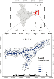
Spatial Assessment of Flood Susceptibility in Assam, India: A Comparative Study of Frequency Ratio and Shannon’s Entropy Models
- Research Article
- Published: 14 February 2024
- Volume 52 , pages 343–358, ( 2024 )
Cite this article

- Leena Chetia ORCID: orcid.org/0009-0007-6588-984X 1 &
- Saikat Kumar Paul 1
209 Accesses
Explore all metrics
Flooding is a common and catastrophic natural event that has serious consequences for both human and nature. The assessment of flood susceptibility within watersheds and the implementation of measures to mitigate flood-related impacts and damages are integral aspects of environmental, water resources and disaster management. Assam is significantly impacted by recurring flood events consisting of multiple waves. Consequently, it is imperative to precisely identify the areas susceptible to flooding. Therefore, this research aims to assess the capability of the Frequency Ratio (FR) and Shannon’s Entropy (SE) model for mapping flood susceptibility; and to identify extremely flood prone locations in Assam, India. The study was conducted in four main stages. Firstly, a flood inventory map was developed by using historic records (1998 to 2017) from the Assam Water Resources Department (AWRD), Assam State Disaster Management Authority (ASDMA), and extensive field surveys. A total of 1630 flood occurrence points were extracted; and of these 75% were randomly selected for model training and 25% for validation. Secondly, nine flood conditioning factors were considered, including elevation, aspect, distance from river, drainage density, Land-use and Land-cover (LULC), rainfall, geomorphology, Topographic Wetness Index (TWI), and Normalised Difference Vegetative Index (NDVI). The thematic layers were prepared in a Geographic Information System (GIS). Thirdly, flood susceptibility maps (FSMs) were generated by applying FR and SE models, using the flood conditioning factors and the occurrence locations. The FSMs were classified into five classes. Finally, the predictive capability of FR and SE models and the validation was done by using Receiver Operating Characteristic (ROC) curves and computing the Area Under Curves (AUC). The AUC for the FR model was 0.748, and the SE model, it was 0.761. The validation results suggests that the SE model is more suitable for predicting flood susceptibility in the study area. The study makes a unique contribution by identifying the flood susceptible zones in Assam, a state afflicted by recurrent floods. The derived FSMs of the region can be used for effective decision making in flood management, as well as for strategic planning and mitigation measures toward flood events in the future.
This is a preview of subscription content, log in via an institution to check access.
Access this article
Price includes VAT (Russian Federation)
Instant access to the full article PDF.
Rent this article via DeepDyve
Institutional subscriptions
Flood susceptibility mapping using geospatial frequency ratio technique: a case study of subarnarekha river basin, india.

Flood Susceptibility Mapping Using a Frequency Ratio Model: A Case Study of Chai Nat Province, Thailand

GIS-based flood susceptibility mapping of the lower Bagmati basin in Bihar, using Shannon’s entropy model
Availability of data and material.
Not applicable.
Code Availability
Not Applicable.
Al-Hinai, H., & Abdalla, R. (2021). Mapping coastal flood susceptible areas using shannon’s entropy model: The case of muscat governorate, Oman. ISPRS International Journal of Geo-Information , 10 (4). https://doi.org/10.3390/ijgi10040252
Ali, S. A., Parvin, F., Pham, Q. B., Vojtek, M., Vojteková, J., Costache, R., Linh, N. T. T., Nguyen, H. Q., Ahmad, A., & Ghorbani, M. A. (2020). GIS-based comparative assessment of flood susceptibility mapping using hybrid multi-criteria decision-making approach, naïve Bayes tree, bivariate statistics and logistic regression: A case of Topľa basin, Slovakia. Ecological Indicators, 117 (June), 106620. https://doi.org/10.1016/j.ecolind.2020.106620
Article Google Scholar
Arshad, A., Zhang, Z., Zhang, W., & Dilawar, A. (2020). Mapping favorable groundwater potential recharge zones using a GIS-based analytical hierarchical process and probability frequency ratio model: A case study from an agro-urban region of Pakistan. Geoscience Frontiers, 11 (5), 1805–1819. https://doi.org/10.1016/j.gsf.2019.12.013
Aryal, K., Apan, A., & Maraseni, T. (2023). Comparing global and local land cover maps for ecosystem management in the Himalayas. Remote Sensing Applications: Society and Environment , 30 (November 2022), 100952. https://doi.org/10.1016/j.rsase.2023.100952
Band, S. S., Janizadeh, S., Pal, S. C., Saha, A., Chakrabortty, R., Melesse, A. M., & Mosavi, A. (2020). Flash flood susceptibility modeling using new approaches of hybrid and ensemble tree-based machine learning algorithms. Remote Sensing, 12 (21), 1–23. https://doi.org/10.3390/rs12213568
Benito, G., Rico, M., Sánchez-Moya, Y., Sopeña, A., Thorndycraft, V. R., & Barriendos, M. (2010). The impact of late Holocene climatic variability and land use change on the flood hydrology of the Guadalentín River, southeast Spain. Global and Planetary Change, 70 (1–4), 53–63. https://doi.org/10.1016/j.gloplacha.2009.11.007
Article ADS Google Scholar
Bonham-Carter, G. F. (1994). Computer methods in the geosciences: Geographic information systems for geoscientists : Modelling with GIS . p. 402.
Bouilloud, L., Delrieu, G., Boudevillain, B., & Kirstetter, P. E. (2010). Radar rainfall estimation in the context of post-event analysis of flash-flood events. Journal of Hydrology, 394 (1–2), 17–27. https://doi.org/10.1016/j.jhydrol.2010.02.035
Bronstert, A. (2003). Floods and climate change: Interactions and impacts. Risk Analysis , 23 (3), 545–557. https://doi.org/10.1111/1539-6924.00335
Article PubMed Google Scholar
Cao, C., Xu, P., Wang, Y., Chen, J., Zheng, L., & Niu, C. (2016). Flash flood hazard susceptibility mapping using frequency ratio and statistical index methods in coalmine subsidence areas. Sustainability (Switzerland) , 8 (9). https://doi.org/10.3390/su8090948
Chen, H., Liang, Q., Liu, Y., & Xie, S. (2018). Hydraulic correction method (HCM) to enhance the efficiency of SRTM DEM in flood modeling. Journal of Hydrology, 559 , 56–70. https://doi.org/10.1016/j.jhydrol.2018.01.056
Chen, W., Li, Y., Xue, W., Shahabi, H., Li, S., Hong, H., Wang, X., Bian, H., Zhang, S., Pradhan, B., & Ahmad, B. B. (2020). Modeling flood susceptibility using data-driven approaches of naïve Bayes tree, alternating decision tree, and random forest methods. Science of the Total Environment, 701 , 134979. https://doi.org/10.1016/j.scitotenv.2019.134979
Article ADS CAS PubMed Google Scholar
Chu, H., Wu, W., Wang, Q. J., Nathan, R., & Wei, J. (2020). An ANN-based emulation modelling framework for flood inundation modelling: Application, challenges and future directions. Environmental Modelling and Software , 124 (November 2019), 104587. https://doi.org/10.1016/j.envsoft.2019.104587
CRED. (2020). Human Cost of Disasters (2000–2019). Human Cost of Disasters , 61 , 1–2. https://doi.org/10.18356/79b92774-en
Das, S. (2019). Geospatial mapping of flood susceptibility and hydro-geomorphic response to the floods in Ulhas basin, India. Remote Sensing Applications: Society and Environment, 14 (January), 60–74. https://doi.org/10.1016/j.rsase.2019.02.006
Dewan, A. M., Islam, M. M., Kumamoto, T., & Nishigaki, M. (2007). Evaluating flood hazard for land-use planning in greater Dhaka of Bangladesh using remote sensing and GIS techniques. Water Resources Management, 21 (9), 1601–1612. https://doi.org/10.1007/s11269-006-9116-1
Edamo, M. L., Ukumo, T. Y., Lohani, T. K., Ayana, M. T., Ayele, M. A., Mada, Z. M., & Abdi, D. M. (2022). A comparative assessment of multi-criteria decision-making analysis and machine learning methods for flood susceptibility mapping and socio-economic impacts on flood risk in Abela-Abaya floodplain of Ethiopia. Environmental Challenges , 9 (July). https://doi.org/10.1016/j.envc.2022.100629
Elvis, B. W. W., Arsène, M., Théophile, N. M., Bruno, K. M. E., & Olivier, O. A. (2022). Integration of shannon entropy (SE), frequency ratio (FR) and analytical hierarchy process (AHP) in GIS for suitable groundwater potential zones targeting in the Yoyo river basin, Méiganga area, Adamawa Cameroon. Journal of Hydrology: Regional Studies , 39 (January). https://doi.org/10.1016/j.ejrh.2022.100997
Erena, S. H., & Worku, H. (2018). Flood risk analysis: Causes and landscape based mitigation strategies in Dire Dawa city, Ethiopia. Geoenvironmental Disasters , 5 (1). https://doi.org/10.1186/s40677-018-0110-8
Fang, X., Zhang, Y., Xiang, Y., Zou, J., Li, X., Hao, C., & Wang, J. (2023). A spatial model for coastal flood susceptibility assessment using the 2D-SPR method with complex network theory: A case study of a reclamation island in Zhoushan, China. Environmental Impact Assessment Review, 98 (36), 106953. https://doi.org/10.1016/j.eiar.2022.106953
Gaume, E., Bain, V., Bernardara, P., Newinger, O., Barbuc, M., Bateman, A., Blaškovičová, L., Blöschl, G., Borga, M., Dumitrescu, A., Daliakopoulos, I., Garcia, J., Irimescu, A., Kohnova, S., Koutroulis, A., Marchi, L., Matreata, S., Medina, V., Preciso, E., et al. (2009). A compilation of data on European flash floods. Journal of Hydrology , 367 (1–2), 70–78. https://doi.org/10.1016/j.jhydrol.2008.12.028
Ghosh, A., Dey, P., & Ghosh, T. (2022). Integration of RS-GIS with frequency ratio, fuzzy logic, logistic regression and decision tree models for flood susceptibility prediction in lower gangetic plain: A study on Malda District of West Bengal, India. Journal of the Indian Society of Remote Sensing, 50 (9), 1725–1745. https://doi.org/10.1007/s12524-022-01560-5
Goffi, A., Stroppiana, D., Brivio, P. A., Bordogna, G., & Boschetti, M. (2020). Towards an automated approach to map flooded areas from Sentinel-2 MSI data and soft integration of water spectral features. International Journal of Applied Earth Observation and Geoinformation , 84 (August 2019), 101951. https://doi.org/10.1016/j.jag.2019.101951
Guhathakurta, P., Khedikar, S., Menon, P., Prasad, A. K., Sable, S. T., & Advani, S. C. (2020). Climate research and services observed rainfall variability and changes over Assam State. IMD Annual Report , 16 , 28. ESSO/IMD/HS/Rainfall%0AVariability/16(2020)/40%0AObserved
Haghizadeh, A., Siahkamari, S., Haghiabi, A. H., & Rahmati, O. (2017). Forecasting flood-prone areas using Shannon’s entropy model. Journal of Earth System Science , 126 (3). https://doi.org/10.1007/s12040-017-0819-x
Hong, H., Panahi, M., Shirzadi, A., Ma, T., Liu, J., Zhu, A. X., Chen, W., Kougias, I., & Kazakis, N. (2018). Flood susceptibility assessment in Hengfeng area coupling adaptive neuro-fuzzy inference system with genetic algorithm and differential evolution. Science of the Total Environment, 621 , 1124–1141. https://doi.org/10.1016/j.scitotenv.2017.10.114
Horton, R. E. (1955). Erosional development of streams and their drainage basins, hydrophysical approach to quantitative morphology. Nihon Ringakkai Shi/journal of the Japanese Forestry Society, 37 (12), 555–558. https://doi.org/10.1130/0016-7606(1945)56
Hudson, P., Botzen, W. J. W., Kreibich, H., Bubeck, P., & Aerts, H. J. C. J. (2014). Evaluating the effectiveness of flood damage mitigation measures by the application of propensity score matching. Natural Hazards and Earth System Sciences, 14 (7), 1731–1747. https://doi.org/10.5194/nhess-14-1731-2014
Islam, S., Tahir, M., & Parveen, S. (2022). GIS-based flood susceptibility mapping of the lower Bagmati basin in Bihar, using Shannon’s entropy model. Modeling Earth Systems and Environment, 8 (3), 3005–3019. https://doi.org/10.1007/s40808-021-01283-5
Khosravi, K., Nohani, E., Maroufinia, E., & Pourghasemi, H. R. (2016). A GIS-based flood susceptibility assessment and its mapping in Iran: A comparison between frequency ratio and weights-of-evidence bivariate statistical models with multi-criteria decision-making technique. Natural Hazards, 83 (2), 947–987. https://doi.org/10.1007/s11069-016-2357-2
Kotoky, P., Bezbaruah, D., Baruah, J., & Sarma, J. N. (2005). Nature of bank erosion along the Brahmaputra river channel, Assam, India. Current Science, 88 (4), 634–640.
Google Scholar
Kumari, N., Saco, P. M., Rodriguez, J. F., Johnstone, S. A., Srivastava, A., Chun, K. P., & Yetemen, O. (2020). The grass is not always greener on the other side: Seasonal reversal of vegetation greenness in aspect-driven semiarid ecosystems. Geophysical Research Letters, 47 (15), 1–12. https://doi.org/10.1029/2020GL088918
Lin, J. (1991). Divergence measures based on the Shannon entropy. IEEE Transactions on Information Theory, 37 (1), 145–151. https://doi.org/10.1109/18.61115
Article MathSciNet Google Scholar
Mahanta, R., & Das, D. (2017). Flood induced vulnerability to poverty: Evidence from Brahmaputra Valley, Assam, India. International Journal of Disaster Risk Reduction, 24 (April), 451–461. https://doi.org/10.1016/j.ijdrr.2017.04.014
Matsushita, B., Yang, W., Chen, J., Onda, Y., & Qiu, G. (2007). Sensitivity of the Enhanced Vegetation Index (EVI) and Normalized Difference Vegetation Index (NDVI) to topographic effects: A case study in high-density cypress forest. Sensors, 7 (11), 2636–2651. https://doi.org/10.3390/s7112636
Article ADS PubMed Central PubMed Google Scholar
Meles, M. B., Younger, S. E., Jackson, C. R., Du, E., & Drover, D. (2020). Wetness index based on landscape position and topography (WILT): Modifying TWI to reflect landscape position. Journal of Environmental Management , 255 (September 2019), 109863. https://doi.org/10.1016/j.jenvman.2019.109863
Mind’je, R., Li, L., Amanambu, A. C., Nahayo, L., Nsengiyumva, J. B., Gasirabo, A., & Mindje, M. (2019). Flood susceptibility modeling and hazard perception in Rwanda. International Journal of Disaster Risk Reduction, 38 (April), 101211. https://doi.org/10.1016/j.ijdrr.2019.101211
Moges, D. M., Virro, H., Kmoch, A., Cibin, R., Rohith, A. N., Martínez-Salvador, A., Conesa-García, C., & Uuemaa, E. (2023). How does the choice of DEMs affect catchment hydrological modeling? Science of the Total Environment , 892 (June). https://doi.org/10.1016/j.scitotenv.2023.164627
Nachappa, T. G., Ghorbanzadeh, O., Gholamnia, K., & Blaschke, T. (2020). Multi-hazard exposure mapping using machine learning for the state of Salzburg, Austria. Remote Sensing, 12 (17), 1–24. https://doi.org/10.3390/RS12172757
Natarajan, L., Usha, T., Gowrappan, M., PalpanabhanKasthuri, B., Moorthy, P., & Chokkalingam, L. (2021). Flood susceptibility analysis in Chennai Corporation using frequency ratio model. Journal of the Indian Society of Remote Sensing, 49 (7), 1533–1543. https://doi.org/10.1007/s12524-021-01331-8
NRSC. (2016). No Flood Hazard Atlas for Assam State (1998–2015) .
Panchal, S., & Shrivastava, A. K. (2021). A comparative study of frequency ratio, shannon’s entropy and analytic hierarchy process (Ahp) models for landslide susceptibility assessment. ISPRS International Journal of Geo-Information , 10 (9). https://doi.org/10.3390/ijgi10090603
Paul, G. C., Saha, S., & Hembram, T. K. (2019). Application of the GIS-based probabilistic models for mapping the flood susceptibility in Bansloi Sub-basin of Ganga-Bhagirathi River and their comparison. Remote Sensing in Earth Systems Sciences, 2 (2–3), 120–146. https://doi.org/10.1007/s41976-019-00018-6
Pradhan, B. (2009). Flood susceptible mapping and risk area delineation using logistic regression, GIS and remote sensing. Journal of Spatial Hydrology, 9 (2), 1–18.
Rahmati, O., & Pourghasemi, H. R. (2017). Identification of critical flood prone areas in data-scarce and ungauged regions: A comparison of three data mining models. Water Resources Management, 31 (5), 1473–1487. https://doi.org/10.1007/s11269-017-1589-6
Rahmati, O., Haghizadeh, A., & Stefanidis, S. (2016a). Assessing the accuracy of GIS-based analytical hierarchy process for watershed prioritization; Gorganrood River Basin, Iran. Water Resources Management, 30 (3), 1131–1150. https://doi.org/10.1007/s11269-015-1215-4
Rahmati, O., Pourghasemi, H. R., & Zeinivand, H. (2016b). Flood susceptibility mapping using frequency ratio and weights-of-evidence models in the Golastan Province, Iran. Geocarto International, 31 (1), 42–70. https://doi.org/10.1080/10106049.2015.1041559
Rahmati, O., Zeinivand, H., & Besharat, M. (2016c). Flood hazard zoning in Yasooj region, Iran, using GIS and multi-criteria decision analysis. Geomatics, Natural Hazards and Risk, 7 (3), 1000–1017. https://doi.org/10.1080/19475705.2015.1045043
RazaviTermeh, S. V., Kornejady, A., Pourghasemi, H. R., & Keesstra, S. (2018). Flood susceptibility mapping using novel ensembles of adaptive neuro fuzzy inference system and metaheuristic algorithms. Science of the Total Environment, 615 , 438–451. https://doi.org/10.1016/j.scitotenv.2017.09.262
Article ADS CAS Google Scholar
Rehman, S., & Azhoni, A. (2023). Multihazard assessment of the Sutlej-Beas River basin using bivariate statistical Frequency Ratio (FR) Model and management barriers of land-river interface. Environmental Modeling and Assessment, 28 (4), 673–692. https://doi.org/10.1007/s10666-023-09886-1
Sakthivel, R. (2018). JASC : Journal of Applied Science and Computations ISSN NO : 1076–5131 Flood Susceptibility Mapping Using Frequency Ratio (FR) and Shannon’s Entropy (SE) Models in Nagavathi Sub-Basin, Tamilnadu India Abstract : ISSN NO : 1076–5131 . 5 (9), 757–770.
Salekin, S., Lad, P., Morgenroth, J., Dickinson, Y., & Meason, D. F. (2023). Uncertainty in primary and secondary topographic attributes caused by digital elevation model spatial resolution. CATENA, 231 (April), 107320. https://doi.org/10.1016/j.catena.2023.107320
Samanta, S., Pal, D. K., & Palsamanta, B. (2018). Flood susceptibility analysis through remote sensing, GIS and frequency ratio model. Applied Water Science, 8 (2), 1–14. https://doi.org/10.1007/s13201-018-0710-1
Sapkale, J. B., Sinha, D., Susware, N. K., & Susware, V. N. (2022). Flood hazard zone mapping of Kasari river basin (Kolhapur, India), using remote sensing and GIS techniques. Journal of the Indian Society of Remote Sensing, 50 (12), 2523–2541. https://doi.org/10.1007/s12524-022-01610-y
Sarkar, D., & Mondal, P. (2020). Flood vulnerability mapping using frequency ratio (FR) model: A case study on Kulik river basin, Indo-Bangladesh Barind region. Applied Water Science , 10 (1). https://doi.org/10.1007/s13201-019-1102-x
Sarma, J. N. (2005). Fluvial process and morphology of the Brahmaputra River in Assam, India. Geomorphology , 70 (3–4 SPEC. ISS.), 226–256. https://doi.org/10.1016/j.geomorph.2005.02.007
Schober, B., Hauer, C., & Habersack, H. (2014). A novel assessment of the role of Danube floodplains in flood hazard reduction (FEM method). Natural Hazards, 75 (1), 33–50. https://doi.org/10.1007/s11069-013-0880-y
Shahabi, H., Shirzadi, A., Ghaderi, K., Omidvar, E., Al-Ansari, N., Clague, J. J., Geertsema, M., Khosravi, K., Amini, A., Bahrami, S., Rahmati, O., Habibi, K., Mohammadi, A., Nguyen, H., Melesse, A. M., Ahmad, B. Bin, & Ahmad, A. (2020). Flood detection and susceptibility mapping using Sentinel-1 remote sensing data and a machine learning approach: Hybrid intelligence of bagging ensemble based on K-Nearest Neighbor classifier. Remote Sensing , 12 (2). https://doi.org/10.3390/rs12020266
Shannon, C. E. (1948). A mathematical theory of communication. Bell System Technical Journal, 27 (4), 623–656. https://doi.org/10.1002/j.1538-7305.1948.tb00917.x
Shastry, A., Carter, E., Coltin, B., Sleeter, R., McMichael, S., & Eggleston, J. (2023). Mapping floods from remote sensing data and quantifying the effects of surface obstruction by clouds and vegetation. Remote Sensing of Environment, 291 (April), 113556. https://doi.org/10.1016/j.rse.2023.113556
Singh, S. K. (2008). Erosion and weathering in the Brahmaputra River System. Large Rivers: Geomorphology and Management , 373–393. https://doi.org/10.1002/9780470723722.ch18
Tehrany, M. S., Pradhan, B., & Jebur, M. N. (2014). Flood susceptibility mapping using a novel ensemble weights-of-evidence and support vector machine models in GIS. Journal of Hydrology, 512 , 332–343. https://doi.org/10.1016/j.jhydrol.2014.03.008
Tehrany, M. S., Pradhan, B., Mansor, S., & Ahmad, N. (2015). Flood susceptibility assessment using GIS-based support vector machine model with different kernel types. CATENA, 125 , 91–101. https://doi.org/10.1016/j.catena.2014.10.017
Tehrany, M. S., Shabani, F., NeamahJebur, M., Hong, H., Chen, W., & Xie, X. (2017). GIS-based spatial prediction of flood prone areas using standalone frequency ratio, logistic regression, weight of evidence and their ensemble techniques. Geomatics, Natural Hazards and Risk, 8 (2), 1538–1561. https://doi.org/10.1080/19475705.2017.1362038
Towfiqul Islam, A. R. M., Talukdar, S., Mahato, S., Kundu, S., Eibek, K. U., Pham, Q. B., Kuriqi, A., & Linh, N. T. T. (2021). Flood susceptibility modelling using advanced ensemble machine learning models. Geoscience Frontiers , 12 (3). https://doi.org/10.1016/j.gsf.2020.09.006
Zhang, G., Chen, W., Li, G., Yang, W., Yi, S., & Luo, W. (2020). Lake water and glacier mass gains in the northwestern Tibetan Plateau observed from multi-sensor remote sensing data: Implication of an enhanced hydrological cycle. Remote Sensing of Environment , 237 (June 2019), 111554. https://doi.org/10.1016/j.rse.2019.111554
Download references
Acknowledgements
The authors would like to acknowledge the ESRI for providing the Land-use-Land-cover data, The Shuttle Radar Topography Mission (SRTM) for Digital Elevation Model (DEM) data, Landsat for Landsat 8 OLI data, Geological Survey of India (GSI) for Geomorphology data, India Meteorological Department (IMD) for rainfall data for the research. The authors are also grateful to Assam State Disaster Management Authority and Assam Water Resources Department for flooded villages data. Authors also acknowledge the GATE scholarship provided by All India Council for Technical Education, Ministry of Human Resource and Development (MHRD), Govt. of India.
Leena Chetia is grateful to the All India Council for Technical Education, Ministry of Human Resource and Development (MHRD), Government of India for awarding the GATE scholarship, which has been of great assistance in conducting this research.
Author information
Authors and affiliations.
Department of Architecture and Regional Planning, Indian Institute of Technology Kharagpur, Kharagpur, West Bengal, India
Leena Chetia & Saikat Kumar Paul
You can also search for this author in PubMed Google Scholar
Contributions
The study’s complete execution, including data collection, analysis, and interpretation, was performed by Leena Chetia. By aiding in the development of the methodology and offering advice at various points throughout the research, Saikat Paul has acted as a mentor for this study.
Corresponding author
Correspondence to Leena Chetia .
Ethics declarations
Conflicts of interest.
The authors declare that they have no conflict of interest.
Additional information
Publisher's note.
Springer Nature remains neutral with regard to jurisdictional claims in published maps and institutional affiliations.
About this article
Chetia, L., Paul, S.K. Spatial Assessment of Flood Susceptibility in Assam, India: A Comparative Study of Frequency Ratio and Shannon’s Entropy Models. J Indian Soc Remote Sens 52 , 343–358 (2024). https://doi.org/10.1007/s12524-023-01798-7
Download citation
Received : 31 May 2023
Accepted : 05 December 2023
Published : 14 February 2024
Issue Date : February 2024
DOI : https://doi.org/10.1007/s12524-023-01798-7
Share this article
Anyone you share the following link with will be able to read this content:
Sorry, a shareable link is not currently available for this article.
Provided by the Springer Nature SharedIt content-sharing initiative
- Flood susceptibility
- Remote sensing and GIS
- Frequency ratio
- Shannon’s entropy
- Natural disaster
- Assam flood
- Find a journal
- Publish with us
- Track your research
- Business Today
- India Today
- India Today Gaming
- Cosmopolitan
- Harper's Bazaar
- Brides Today
- Aajtak Campus
- Magazine Cover Story Editor's Note Deep Dive Interview The Buzz
- BT TV Market Today Easynomics Drive Today BT Explainer
- Market Today Trending Stocks Indices Stocks List Stocks News Share Market News IPO Corner
- Tech Today Unbox Today Authen Tech Tech Deck Tech Shorts
- Money Today Tax Investment Insurance Tools & Calculator
- Mutual Funds
- Industry Banking IT Auto Energy Commodities Pharma Real Estate Telecom
- Visual Stories

INDICES ANALYSIS
Mutual funds.
- Cover Story
- Editor's Note
- Market Today
- Drive Today
- BT Explainer
- Trending Stocks
- Stocks List
- Stocks News
- Share Market News
- Unbox Today
- Authen Tech
- Tech Shorts
- Tools & Calculator
- Commodities
- Real Estate
- Election with BT
- Economic Indicators
- BT-TR GCC Listing
Assam floods: Haflong railway station inundated due to heavy downpour; passengers rescued
Haflong station in the Dima Hasao district of Assam has been completely inundated due to heavy rains and mudslide. This has impacted train services that come under this section of the Northeast Frontier Railway (NFR).
- Updated May 17, 2022, 12:06 PM IST

Empty passenger train stranded at worst landslide and flood hit Assam’s New Halflong Station of Dima Hasao being derailed by the strong gush of water and mud flowing down the hills. #AssamFloods #heavyrainfall #NorthEast @CMOfficeAssam @RailMinIndia @himantabiswa pic.twitter.com/etLolfgVBB var ssoCookieUid=getLoginCookie('itg_sso_uid');var isSubsPremium=document.cookie.match(new RegExp('(^| )' + 'subscribed_ads_free' + '=([^;]+)'));var isPVisible;if(ssoCookieUid == ''){isPVisible=true;}else{if(isSubsPremium==null){isPVisible = true;}else{isPVisible = false;}};if(isPVisible == true){if(is_sso_check==true) { if(atViewPort=='desktop') { googletag.cmd.push(function() { googletag.defineSlot('/1007232/Businesstoday_ROS_Desktop_300x250_MTF', [[300, 250], [336, 280]], 'div-gpt-ad-1').addService(googletag.pubads()); googletag.pubads().enableSingleRequest();googletag.pubads().setTargeting('category', ['latest', 'trends', 'story', '333871','Businesstoday_story_loop_0']);googletag.pubads().setTargeting('keywords', ['Assam floods','Haflong railway station','Dima Hasao','Dima Hasao train','Dima Hasao flood','Dima Hasao train flooded','Haflong railway station flooded','Haflong railway station trains','Haflong railway station trains cancelled','Assam floods news','Assam floods update']);googletag.pubads().collapseEmptyDivs(); googletag.enableServices(); }); } else { googletag.cmd.push(function() {googletag.defineSlot('/1007232/BT_ROS_Mobile_300x250_Inartilce', [300, 250], 'div-gpt-ad-1').addService(googletag.pubads()); googletag.pubads().enableSingleRequest();googletag.pubads().setTargeting('category', ['latest', 'trends', 'story', '333871','Businesstoday_story_loop_0']);googletag.pubads().setTargeting('keywords', ['Assam floods','Haflong railway station','Dima Hasao','Dima Hasao train','Dima Hasao flood','Dima Hasao train flooded','Haflong railway station flooded','Haflong railway station trains','Haflong railway station trains cancelled','Assam floods news','Assam floods update']);googletag.pubads().collapseEmptyDivs(); googletag.enableServices();}); } }} var ssoCookieUid=getLoginCookie('itg_sso_uid');var isSubsPremium=document.cookie.match(new RegExp('(^| )' + 'subscribed_ads_free' + '=([^;]+)'));var isPVisible;if(ssoCookieUid == ''){isPVisible=true;}else{if(isSubsPremium==null){isPVisible = true;}else{isPVisible = false;}};if(isPVisible == true){if(is_sso_check==true) { if(atViewPort=='desktop') { googletag.cmd.push(function() { googletag.display('div-gpt-ad-1'); }); } else {googletag.cmd.push(function() { googletag.display('div-gpt-ad-1'); }); } } else { document.getElementById('div-gpt-ad-1').style.display='none'; }} — PRATEEK BAJPAI (@prateekbajpai07) May 16, 2022
The Northeast Frontier Railway shared an update on the rescue operations at the Haflong Railway station. It tweeted, “Timely action by NF Railway has led to successful evacuation of all passengers of train no. 15616 stranded at Ditokcherra. The last special train left KM 135 evacuating 180 passengers from here. Salute to all unsung heroes working day and night in this difficult situation.”
Timely action by NF Railway has led to successful evacuation of all passengers of train no. 15616 stranded at Ditokcherra. The last spl train left KM 135 evacuating 180 passengers from here. Salute to all unsung heroes working day & night in this difficult situation @RailMinIndia pic.twitter.com/ErzhiP9rO7 — Northeast Frontier Railway (@RailNf) May 16, 2022
Assam Chief Minister Himata Biswa Sarma took to Twitter and wrote, “With heavy rains, come landslides and consequent disruption in communication. Happy that 119 stranded aged and ailing train passengers could be safely airlifted from Dima Hasao district. Kudos to all agencies Army, IAF, Railways, District Administration, Police and ASDMA for coordinated action.”
With heavy rains, come landslides & consequent disruption in communication. Happy that 119 stranded aged & ailing train passengers could be safely airlifted from Dima Hasao district. Kudos to all agencies Army, IAF, Railways, Dist Admn, Police & ASDMA for coordinated action — Himanta Biswa Sarma (@himantabiswa) May 16, 2022
#WATCH | Indian Air Force airlifted and evacuated civilians who were stranded in a train at Ditokcherra railway station in Dima Hasao district of Assam at the request of the civil administration: IAF pic.twitter.com/FfVRa4S7M6 — ANI (@ANI) May 15, 2022
Torrential rains washed away a portion of the road in the Haflong area. National highway between Haflong and Silchar area has also been impacted as water rose on the highway near Kapurcherra in the hill district, as per an ANI report. Haflong-Lanka road has also been affected due to heavy landslide in various areas.
Over 2 lakh people across 24 districts including Cachar, Charaideo, Darrang, Dhemaji, Dibrugarh and Dima-Hasao have been affected by the current flood situation in Assam. Seven people have lost their lives so far in floods and landslides, as per the Assam State Disaster Management Authority.
- #assam floods
- #haflong railway station
- #dima hasao
- #dima hasao flood
- #dima hasao train
TOP STORIES

- Advertise with us
- Privacy Policy
- Terms and Conditions
- Press Releases
Copyright©2024 Living Media India Limited. For reprint rights: Syndications Today

Add Business Today to Home Screen
The Economic Times daily newspaper is available online now.
Sweltering heat, flash floods, 'disappearing' spring season - india's weather story so far in 2024.
Extreme weather events in the first five months of 2024 in north India have caused deaths, floods, and landslides in the northeast, with a spring season that may soon disappear from the calendar.

D-Street on party mode for a likely Modi 3.0. Track market euphoria here
Read More News on
(Catch all the Business News , Breaking News , Sikkim Election Results News , Arunachal Pradesh Election Result News Election Results News Events and Latest News Updates on The Economic Times .)
Subscribe to The Economic Times Prime and read the ET ePaper online.

Awfis vs. REITs: Which is the best option for investors to benefit from office realty boom?

Don’t be afraid of D-Street’s ‘fear index’, weigh these 3 factors instead

Is India the next global beauty retail destination?

Inside the unsettling chaos at the India-Myanmar border

Will the RBI bring India’s gold back from London and Switzerland?

Stock Radar: Up 40% from March lows! V-shaped recovery pushes FMCG scrip to fresh 52-week high in May
Find this comment offensive?
Choose your reason below and click on the Report button. This will alert our moderators to take action
Reason for reporting:
Your Reason has been Reported to the admin.

To post this comment you must
Log In/Connect with:
Fill in your details:
Will be displayed
Will not be displayed
Share this Comment:
Stories you might be interested in

‘Cape of Storms’ – climate researchers explain Cape Town’s recent extreme weather

Research Officer, Climate System Analysis Group, University of Cape Town

PhD student, University of Cape Town
Disclosure statement
Sabina Abba Omar received PhD funding from the South African National Research Foundation
Stefaan Conradie received PhD funding from the South African National Research Foundation and the Climate System Analysis Group.
University of Cape Town provides funding as a partner of The Conversation AFRICA.
View all partners
A severe storm hit South Africa’s Western Cape province between 6 and 9 April 2024 , with extreme winds gusting at up to 135km/h . The storm left a trail of destruction across Cape Town and surrounding areas – at least 1,500 people were left homeless after the high winds fanned fires through their communities, burning homes to the ground.
Sabina Abba Omar and Stefaan Conradie are climate researchers who have studied rainfall variability and weather extremes around Cape Town. They explain some of the factors behind the storms.
What’s unique about Cape Town’s climate?
Cape Town and the surrounding western coastal belt (the Cape Town region) is the only winter rainfall region in southern Africa. The majority of southern Africa gets rainfall primarily in summer.
In Cape Town’s winter, westerly winds bring cold fronts resulting in cold, wet and windy weather. About 70% of the extreme winter rainfall over this area occurs when cold fronts shepherd in atmospheric rivers – long, narrow channels in the air along which enormous amounts of water are transported. They tend to cause extreme rain when they hit mountains.
Read more: What is an atmospheric river? With flooding and mudslides in California, a hydrologist explains the good and bad of these storms and how they're changing
However, the Cape Town region can also experience extreme storms outside winter. This happens with some of Cape Town’s storms that are classified as cut-off lows – isolated wells of cold air in the upper atmosphere which tend to move slowly, often dropping large amounts of rainfall in one place.
Unlike cold fronts, cut-off lows can form at any time of year . Near Cape Town they usually occur with south-easterly winds. They are the most common cause of the “ black south-easter ” phenomenon – when the south-easter wind, usually associated with fair weather, brings in dark, thick clouds.
Because Cape Town is highly dependent on rain for its water supplies, heavy rains from cut-off lows can also be useful in filling up the city’s dams during times of drought. For example, in 2017 there were very few cut-off lows , contributing to 2017 being the driest year in the Cape Town region’s record, spanning over 100 years.
What severe weather has affected the Cape Town region in the last two years?
A series of severe wind and rain storms occurred in the area in 2022 and 2023.
Extreme rains in December 2022 in isolated parts of the Western Cape were the heaviest since at least 1979, leading to flooded roads and landslides. This was linked to a cut-off low.
In March 2023, a series of cut-off lows brought the wettest March for Cape Town’s iconic Table Mountain since at least 1893. Then atmospheric rivers brought widespread, deadly and destructive flooding to the Cape Town region in June, cutting off some communities from the outside world .
Another three months later in September 2023, another cut-off low storm happened , killing at least eight people and causing an estimated R1.4 billion (US$75 million) worth of damage to agriculture alone.
What does the research say?
Research relating climate change to such storms over the Cape Town region is inconclusive.
On the one hand, climate change attribution studies have shown that climate change has intensified extreme rainfall events in many parts of the world. This is because as the Earth warms, more water evaporates from warmer oceans into a warmer atmosphere, capable of holding more moisture. Hence, more rain can fall, more quickly.
The Cape Town region is expected to become drier due to climate change . As a result, attribution studies have identified a significantly increased risk of droughts as bad as the Day Zero event .
Read more: Is climate change to blame for extreme weather events? Attribution science says yes, for some – here's how it works
The term “ Day Zero ” was coined by the Western Cape government for the day when water supply to most users would need be cut because the dams would no longer have enough water to supply taps. Since 2016, several such anticipated Day Zero events in South Africa have been narrowly averted .
It would be understandable to think that increasing droughts mean that flooding decreases. However, over the Mediterranean region, whose climate is broadly similar to Cape Town’s, climate change is linked to an increased risk of both drought and flooding. This was the conclusion of an attribution study after Storm Daniel caused the world’s deadliest flood in decades over coastal Libya.

Another consideration is that cold fronts are expected to weaken and affect South Africa less often in the future. Studies using climate models project a future reduction in extreme rains over Cape Town.
The only study on future climate change and cut-off lows over South Africa concludes that cut-off lows may happen less often . But those that do happen may be wetter . Many questions remain.
Where does this leave us?
More research on the link between Cape Town’s storms and climate change is urgently needed. We know that cut-off lows are a major severe weather risk in the area. Better understanding of how cut-off lows may change in the future could help us prepare for their impacts.
The timely and widespread distribution of early warnings issued when such storms are expected is essential. We should all take note of these warnings.
- Climate crisis
- Cape Town fires
- Atmospheric rivers
Head of School, School of Arts & Social Sciences, Monash University Malaysia
Chief Operating Officer (COO)
Clinical Teaching Fellow
Data Manager
Director, Social Policy
- River City Live
- Newsletters
WEATHER ALERT
A river flood warning in effect for Columbia County
Defense makes last pitch to keep deputy’s killer off death row as woman who tried to help him escape sentenced, patrick mcdowell will be officially sentenced later after jury recommended death penalty.
Jenese Harris , Anchor/Meteorologist
Ashley Harding , Reporter/Weekend Anchor
NASSAU COUNTY, Fla. – Patrick McDowell ’s attorneys made one last push in court Monday morning to keep the man who pleaded guilty to killing a Nassau County deputy off death row.
But it might be an uphill climb to sway the judge, considering McDowell himself encouraged jurors to recommend the death penalty for him during his sentencing trial in April.
Recommended Videos
The jury obliged with an 11 to 1 vote to recommend a death sentence for McDowell, who admitted to gunning down Nassau County Deputy Joshua Moyers during a traffic stop in 2021.
On Monday, McDowell and his attorneys, along with prosecutors, were back in court for what’s known as a Spencer hearing. It’s the last chance for attorneys to present evidence to the court in hopes of swaying the judge to set aside the jury’s death penalty recommendation and impose a life sentence.
McDowell was not sentenced on Monday. Typically, the judge will take time to consider the arguments and set a later date for the sentencing.
RELATED | Following death sentence for deputy’s killer, Army veteran urges other veterans to address mental health
Gene Nichols, a local defense attorney not affiliated with the case, explained that it is “incredibly rare” to see a case where a judge sets aside a jury recommendation.
“Judges will typically want to side with a jury, especially in a case like this. It has happened in the past, but for a number that strong, and based upon the evidence that came out in this case,” Nichols said. “I’d be very surprised for the court to overturn this death sentence.”
McDowell’s attorneys also have to contend with his own statements during the sentencing trial, including “I can’t take away the pain I’ve caused, but I can pay for it. So make me pay for it.”
RELATED | Drug use, PTSD, military service influenced Patrick McDowell’s state-of-mind on night he killed deputy, expert testifies
“Because of the statements that he already made in the sentencing hearing, which in essence was, ‘put me to death,’” Nichols said. “It puts his defense team in a very awkward position. And then it really only gives them the route of, there must be a mental health reason why he has taken the position that he has. Whether there is or not, we’ll potentially hear that during the hearing.”
Watch McDowell’s full statement in the video below:
Woman sentenced as accessory
A Jacksonville woman accused of trying to help who pleaded guilty to accessory after the fact for trying to help McDowell escape capture was sentenced Monday, following McDowell’s hearing.
Breiana Tole was in communication with McDowell during the multi-day manhunt and was arrested when she drove to the sports complex where he was hiding, intending to help him escape.
Tole was sentenced to three years in prison, followed by three years of probation. She was given credit for 980 days served in jail since her guilty plea. That means she only has about three months of prison time to serve.
Copyright 2024 by WJXT News4JAX - All rights reserved.
About the Authors
Jenese harris.
Veteran journalist and Emmy Award winning anchor
Ashley Harding
Ashley Harding joined the Channel 4 news team in March 2013. She reports for and anchors The Morning Show.
Click here to take a moment and familiarize yourself with our Community Guidelines.
We've detected unusual activity from your computer network
To continue, please click the box below to let us know you're not a robot.
Why did this happen?
Please make sure your browser supports JavaScript and cookies and that you are not blocking them from loading. For more information you can review our Terms of Service and Cookie Policy .
For inquiries related to this message please contact our support team and provide the reference ID below.
- LIVE DISCOURSE
- BLOG / OPINION
- SUBMIT PRESS RELEASE
- Advertisement
- Knowledge Partnership
- Media Partnership
Countdown to Decision: Assam's Lok Sabha Vote Results Day
The counting of votes for assam's 14 lok sabha seats, involving 143 candidates, commences. key figures such as sarbananda sonowal and gaurav gogoi are in the fray. the process will be carried out across 152 halls in the state, with extensive security and logistical arrangements ensuring smooth operations despite ongoing floods..

The stage is set for a decisive day in Assam as the counting of votes for the state's 14 Lok Sabha seats begins. This critical event will determine the political fate of 143 candidates, including Union Minister Sarbananda Sonowal and Lok Sabha Deputy Leader of Opposition Gaurav Gogoi.
Counting is scheduled to commence at 8 AM across 152 halls situated in 52 centers statewide, with authorities ensuring robust security measures. Given the ongoing floods affecting 13 districts, district authorities have been directed to implement measures for the uninterrupted counting process.
In a coordinated effort, the Assam Election Department is working with the Assam Power Distribution Company Ltd (APDCL) and Bharat Sanchar Nigam Ltd (BSNL) to ensure stable power and internet connectivity. A total of 1,941 counting tables will be operational, with 5,823 personnel and 64 general observers overseeing the meticulous exercise.
Polling transpired in three phases—on April 19, April 26, and May 7—covering constituencies like Dibrugarh, Jorhat, and Guwahati. The NDA alliance fielded candidates across all 14 seats, with BJP contesting 11, AGP 2, and UPPL 1. Concurrently, the Congress, under the United Opposition Forum Assam (UOFA), contested 13 seats, allotting Dibrugarh to the Assam Jatiya Parishad.
Noteworthy contestants include BJP's Topon Gogoi, Pradan Barua, and Congress' Gaurav Gogoi. Chief Minister Himanta Biswa Sarma and key party leaders will be stationed at party headquarters for result updates, with the Congress also setting up war rooms and toll-free complaint numbers for counting-related issues.
Congress's Gaurav Gogoi Triumphs in Assam's Jorhat, BJP Faces Internal Rifts

Breaking Health News: Innovations, Controversies, and Legal Battles

Tragedy in Gaza: The Loss of Dr. Sireen Al-Attar and Its Impact on Healthcar...

New Zealand's Tawhaki: Launchpad for the Future of Aerospace

Prime Minister Shehbaz Sharif Embarks on Strategic Visit to China
Latest news, columbia university ensures safety for students amid israel-hamas protests, judge reduces bayer verdict in roundup cancer case, coco gauff shines at french open, mlb lifetime ban for marcano, mavs extend gm contract, us domestic news roundup: biden’s france trip, immigration measures, and more.

OPINION / BLOG / INTERVIEW
The digital job hunt: harnessing online job portal data in asia and the pacific, tax boost: how revenue fuels economic growth, revolutionizing finance for sustainable futures, transforming agriculture for a sustainable future: world bank’s new toolkit, connect us on.
- ADVERTISEMENT
- KNOWLEDGE PARTNERSHIP
- MEDIA PARTNERSHIP
- Agro-Forestry
- Art & Culture
- Economy & Business
- Energy & Extractives
- Law & Governance
- Science & Environment
- Social & Gender
- Urban Development
- East and South East Asia
- Europe and Central Asia
- Central Africa
- East Africa
- Southern Africa
- West Africa
- Middle East and North Africa
- North America
- Latin America and Caribbean
OTHER LINKS
- Write for us
- Submit Press Release
- Opinion / Blog / Analysis
- Business News
- Entertainment News
- Technology News
- Law-order News
- Lifestyle News
- National News
- International News
OTHER PRODUCTS
Email: [email protected] Phone: +91-720-6444012, +91-7027739813, 14, 15
© Copyright 2024
IMAGES
COMMENTS
That has resulted in one of the worst floods ever recorded in Assam. As of 3 July, flood has affected 1,835,551 people in 26 out of the state's 35 districts and it submerged 471.98 square kilometers (47,198.87 hectares) of cropland. [1] About 200 people have died so far. Earlier on 22 June the floods had affected 5,457,601 people in 32 ...
2020 Assam floods refers to the significant flood event of the Brahmaputra River in the Indian north-eastern state of Assam and coincided with the COVID-19 pandemic.Initial flooding started in May 2020 due to heavy rainfall affecting 30,000 and destroying crops across 5 districts. As of October 2020 the floods affected over five million people, claiming the lives of 123 people, with an ...
The current situation is summarised below: Assam, a state prone to flooding and erosion, has been inundated with flooding and the resulting landslides for the past five days, with 28 districts ...
New Delhi CNN —. Nearly half a million people in northeast India have been affected by severe flooding after heavy rains battered the region, turning roads into rivers and submerging entire ...
The study area witnessed major floods in the years 2000 and 2020 (Flood Hazard Atlas, Assam State Disaster Management Authority 2016; Sharma et al. 2021; Water Resources, Government of Assam 2022 ...
Rahisuddin and his family are one of the millions who have been hit by this year's flood in Assam. As per the latest flood bulletin released by the Assam State Disaster Management Authority (ASDMA), 31,54,556 people in 2,675 villages in 26 districts are currently affected. As many as 3,12,085 people are currently staying in 560 relief camps ...
With overall reduction in rainfall, 2nd wave of floods in Assam that started on 14 June has improved considerably. As of 7 July, 0.91 million people including 0.23 million children and 0.32 ...
Architectural innovations are helping the community adapt to the annual flood hazard and reduce disaster risk in some of the region's most flood-prone areas. Assam's Dhemaji district which borders Arunachal Pradesh is one of India's most flood-prone areas. In 2022, over 100,000 people in the district were affected by three waves of flood.
After the record-breaking rains that led to extreme floods in May and June 2022, Assam is reeling under drought. In this article, we analyse various human-induced and geological factors contributing to this calamity. While the government is pushing for more connectivity through roads and railways coupled with flood control through dams and embankments over the fragile ecology, these measures ...
ASSAM FLOODS-2022. The state of Assam has been facing severe floods and landslides since April 6, 2022 due to pre-monsoon showers followed by south-west monsoon 2022. As per CWC (Central Water Commission) bulletin Rivers namely Kopili, Brahmaputra, Burhidihing & Disang are flowing above danger level, Barak (at BP Ghat, Karimganj at AP Ghat ...
Assam, India Floods 2022 Situation Report 08 July 2022 Highlights • 2nd wave of floods in Assam which started on 14 June has improved considerably. As of 7 July, 0.91 million people including 0.23 million children and 0.32 million women from 707 villages of 14/35 districts are affected. One hundred and eighty six lives lost and 37 people have ...
The flood situation in western Assam has worsened as incessant rainfall continues to lash the state. As of now, nearly 1.2 lakh people have been affected by flooding across 20 districts • The latest bulletin from the Assam SDMA reports that currently, 780 villages are submerged, and approximately 10,7479,85 hectares of crop areas have been ...
The qualitative case study method was adopted and empirical evidence gathered in the recent floods in Assam, India in 2011. The framework was validated using a set of indicators, which were tested over a period of time, and triangulated with the inputs from experts through qualitative interviews.
One of the major steps that Assam could undertake could be to strengthen embankments along the Brahmaputra and other rivers, according to the report. Most flood protection structures in Assam are over 50-60 years old. These were constructed on the main stem of the Brahmaputra and its tributaries way back in the 1960s and 1970s and have become ...
Unrelenting monsoon rains have triggered severe flooding in the Indian state of Assam, killing at least 85 people, displacing tens of thousands residents and drowning rare wildlife in a national park.
Soon-after, some districts faced a drought-like situation forcing farmers to work through disruptions in their cultivation schedule. A year on, in 2023, with Assam receiving excess rain in March, in the current pre-monsoon season, farmers recount how the flood and drought cycle kept them on their toes. In 2022, a pre-monsoon spell from March to ...
The study makes a unique contribution by identifying the flood susceptible zones in Assam, a state afflicted by recurrent floods. The derived FSMs of the region can be used for effective decision making in flood management, as well as for strategic planning and mitigation measures toward flood events in the future. ... A case study of a ...
In the recent flood of Assam in 2020 since May . ... Representative Case Study in India. Article. Jul 2023; ... "A study on the flood mitigation of Assam"-Sharma Deepshika, Gayan Awesha. ...
Seven people have lost their lives so far in floods and landslides, as per the Assam State Disaster Management Authority. Published on: May 17, 2022, 12:06 PM IST IN THIS STORY
Extreme rainfall events (ERE) during the summer monsoon season have been occurring over most parts of India resulting in flooding and immense socio-economic loss. These extremes are becoming a frequent norm in the hilly and mountainous regions of the country such as Assam. Assam received one of the most historical EREs from 14-June 17, 2022. The present study analyses the performance of a ...
Sweltering heatwave in north India that have caused scores of deaths, floods and landslides in the northeast that have affected lakhs of people, a spring season that suggests it could soon "disappear" from the calendar - extreme weather events in the first five months of 2024 have got everyone questioning: where is all this headed? Despite having made predictions to this effect, climate ...
Published: May 30, 2024 2:00am EDT. A severe storm hit South Africa's Western Cape province between 6 and 9 April 2024, with extreme winds gusting at up to 135km/h. The storm left a trail of ...
NASSAU COUNTY, Fla. - Patrick McDowell's attorneys made one last push in court Monday morning to keep the man who pleaded guilty to killing a Nassau County deputy off death row. But it might ...
The study further says that Assam's brick sector primarily relies on coal to fuel the kilns with no usage of alternative materials such as biomass, oil, or gas. Additionally, an average of 18-20 tonnes of wood is used in FCBTKs during the initial firing to evaporate moisture accumulated in the kiln during the rainy season.
Recent flood events (FE) in Germany have shown that the extent and impact of extreme flood events cannot be estimated solely based on numerical models. For analyzing the development of such an event and to develop and implement safety measures more efficiently, additional data must be collected during the event. Within the scope of this research, the possibilities of near real-time recording ...
June 3, 2024 at 4:00 AM PDT. If Chinese electric vehicles are about to flood the world economy — as many US and European officials worry about — then Brazil is a case study worth watching in ...
The counting of votes for Assam's 14 Lok Sabha seats, involving 143 candidates, commences. Key figures such as Sarbananda Sonowal and Gaurav Gogoi are in the fray. The process will be carried out across 152 halls in the state, with extensive security and logistical arrangements ensuring smooth operations despite ongoing floods.